Thursday, May 14, 2009

Expedition Course #2: Political Ecology of Forests, pt. IV

In Ban Hui Hee, a Karen woman is making thread from cotton on a loom. I tried to do the same thing, but somehow - decades of personal experience, I suppose, it didn't produce quite the same results.
I spent around 5 minutes trying to get this shot, and I think I'm pretty proud of it.
I snapped a quick photo of my lunch in Hui Hee before devouring it.
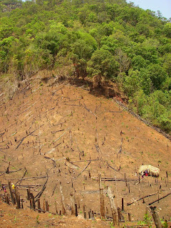
This is a rai [field] in Ban Hui Tong Koe. As a group of twenty-something (2/3 villagers, 1/3 students), it took us a few hours to both make holes and plant rice and other crops on this deceptively steep hill. The land area was about 3 to 4 rai (there are approx. 2.5 rai in one acre). It was hard work, and it shot a good deal of awe for true farmers into me.

A pati [uncle] in Hui Tong Koe examining my machete right before he and another pati taught a group of students a traditional Karen courting song.


Back in Muang Mae Hong Son [Mae Hong Son City], I spent an early morning in the park by a lake, relaxing, reflecting, reading the Good Word, and praying.

Expedition Course #2: Political Ecology of Forests, pt. III

A majestic vista from the top of Doi Pui!

"Rai Day" in Ban Hui Hee. This picture is of the various types of seeds that are interspersed with rice seeds. Around harvest, the villagers will harvest not only rice, but also pumpkins, three species of beans, cucumbers, tomatoes, and numerous others.

"Rai Day" in Hui Hee. The Karen/Pgaganyaw people traditionally employed swidden agriculture. Swidden agriculture is based in the principle of "short planting, long fallow" and involved rotating of planting fields. Ideally and as has been practice, forest plots will be burned and then planted for one year; after harvest, the plot would be left alone for ten years or more and would during that time return to forest. After 10+ years of fallow (during which the fields would be continually rotating), the field, now rehabilitated by the forest, would again be burnt and planted for one year, and the cycle continue. It is a truly amazing and innovative process, which, although it initially seems perhaps suspect, is, when practiced as it has been traditionally, sustainable.

On "Culture Day" in Hui Hee, our group split up into four to makes various Pgaganyaw dishes. Here lie the finished products, which our group heartily devoured.

This was supposed to be a jumping picture. It isn't. I failed. Other than that, though, this picture shows three Karen/Pgaganyaw girls wearing homewoven dresses that unmarried girls traditionally wear.

Expedition Course #2: Political Ecology of Forests, pt. II

The Pgaganyaw alphabet, which I got several lessons on from various host family members as well as one of our expedition leaders, P'Toto. Based on the Burmese alphabet, it was developed by Christian missionaries who came to evangelize the Karen people. I find this an amazing thing, as written language strengthens any cultural-linguistic tradition, giving the sort of stabilizing resilience that the culture certainly would benefit from in times like these when the central Thai government and Thai-language media pushing into the Karen communities.

"Love me, love my fish."
"Honobono bear."
"Oh! Wow Mr. Iceman."
"Afternoon Tea."

The great and hilarious blanket under which I slept for two nights in Ban Naam Hoo.

Nawng Preyawtoo (left) and Nawng Supalah (right) chilling at with Johnnie and I at our house in Naam Hoo.

After hiking through a deluge, me, standing at the peak of Chicken's Head, overlooking the valley in which Ban Hui Hee, our next destination, is situated.

Annie G. snapping a shot near the top of Doi Pui, the tallest mountain in Mae Hong Son province. The mountain, which brought back floods of memories from my travels last summer in Scotland (the resemblance of the peak to what my buddies and I trudged through on the Isle of Skye was uncanny!). The mountain stands, according to one source, at 1722 meters above sea level.

Expedition Course #2: Political Ecology of Forests, pt. I

Our first day of hiking from Ban Pa Ko Lo to Ban Hooah Naam Mae Hong Son involved over twenty stream crossings. This one was my favorite. Nuzzled in between two towering walls of rock, it is through a stream that rages waist deep in rainy season and then over an improvised bridge (a trunk of a tree and some bamboo).

As we entered Ban Hooah Nam Mae Hong Son, we spotted (it was hard not to spot, I suppose) a small herd of water buffalo finding shade underneath one of the village houses. This one buffalo in particular seemed rather interested in the influx of backpack-carrying farang.

A beautiful, misty, cool morning in Hooah Naam.

Mid-day heat relaxation (sabai time).

A towering and gargantuan tree, with its roots ripping through rock. Though the name of the species has since fled from memory, the tree was taller than most houses and had the most impressive roots I've ever marvelled at.